
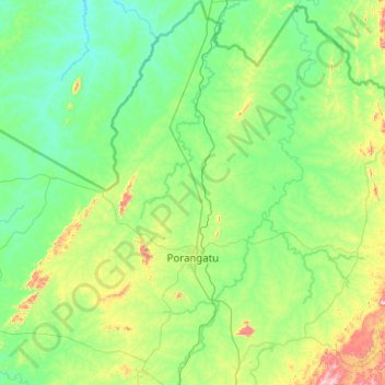
Porangatu topographic map
Interactive map
Click on the map to display elevation.
About this map
Name: Porangatu topographic map, elevation, terrain.
Average elevation: 349 m
Minimum elevation: 223 m
Maximum elevation: 981 m
Important rivers are the Santa Tereza, Cana Brava, Ouro Pintado, Santa Maria and Gregório. The climate is hot, moist tropical, with frequent occurrences of a maximum of 40 °C. The average minimum is 21C, the maximum is 40 °C and the minimum is 21 °C. The elevation is 390 meters above sea level and the highest points are Serra da Sabina and Serra dos Picos.
Other topographic maps
Click on a map to view its topography, its elevation and its terrain.
Abadiânia
Brazil > Goiás > Região Integrada de Desenvolvimento do Distrito Federal e Entorno > Abadiânia
Abadiânia, Região Geográfica Imediata de Anápolis, Região Integrada de Desenvolvimento do Distrito Federal e Entorno, Região Geográfica Intermediária de Goiânia, Goiás, Central-West Region, 72940-000, Brazil
Average elevation: 992 m
Hidrolândia
Brazil > Goiás > Hidrolândia
Hidrolândia, Região Geográfica Imediata de Goiânia, Região Geográfica Intermediária de Goiânia, Goiás, Central-West Region, Brazil
Average elevation: 758 m
Cavalcante
Brazil > Goiás > Cavalcante
Cavalcante, Microrregião da Chapada dos Veadeiros, Mesorregião Norte Goiano, Goiás, Central-West Region, Brazil
Average elevation: 720 m
Chapadão do Céu
Brazil > Goiás > Chapadão do Céu
Chapadão do Céu, Microrregião Sudoeste de Goiás, Mesorregião Sul Goiano, Goiás, Central-West Region, Brazil
Average elevation: 777 m