
Kaitaia topographic map
Interactive map
Click on the map to display elevation.
About this map
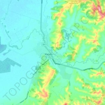
Name: Kaitaia topographic map, elevation, terrain.
Average elevation: 32 m
Minimum elevation: 2 m
Maximum elevation: 144 m
Other topographic maps
Click on a map to view its topography, its elevation and its terrain.
Taipa
New Zealand > Northland > Far North District > Te Hiku Community
Taipa, Te Hiku Community, Far North District, Northland, New Zealand
Average elevation: 17 m
Waiharara
New Zealand > Northland > Far North District > Te Hiku Community
Waiharara, Te Hiku Community, Far North District, Northland, New Zealand
Average elevation: 29 m
Cable Bay
New Zealand > Northland > Far North District > Te Hiku Community
Cable Bay, Te Hiku Community, Far North District, Northland, 0420, New Zealand
Average elevation: 17 m