
Hoegaarden topographic map
Interactive map
Click on the map to display elevation.
About this map
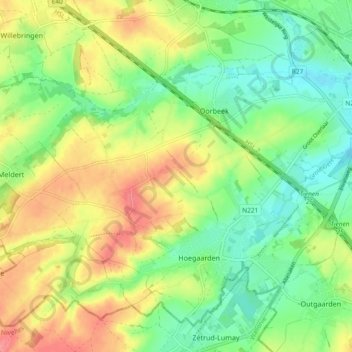
Name: Hoegaarden topographic map, elevation, terrain.
Location: Hoegaarden, Leuven, Vlaams-Brabant, Vlaanderen, 3320, België (50.76275 4.83115 50.81300 4.92429)
Average elevation: 71 m
Minimum elevation: 40 m
Maximum elevation: 111 m
Other topographic maps
Click on a map to view its topography, its elevation and its terrain.
Hoksem
België > Vlaams-Brabant > Leuven > Hoegaarden
Hoksem, Hoegaarden, Leuven, Vlaams-Brabant, 3320, België
Average elevation: 74 m