
Thank you for supporting this site ❤️
Make a donation
Make a donation
Gear up for your next adventure:
As an Amazon Associate, this site earns from qualifying purchases at no extra cost to you.
Tahiti topographic map
Click on the map to display elevation.
Gear up for your next adventure:
As an Amazon Associate, this site earns from qualifying purchases at no extra cost to you.
About this map
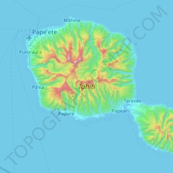
Name: Tahiti topographic map, elevation, terrain.
Location: Tahiti, Windward Islands, French Polynesia, France (-17.88036 -149.62090 -17.49417 -149.12469)
Average elevation: 160 m
Minimum elevation: 0 m
Maximum elevation: 2,139 m
Thank you for supporting this site ❤️
Make a donation
Make a donation
Gear up for your next adventure:
As an Amazon Associate, this site earns from qualifying purchases at no extra cost to you.