
Kadavu topographic map
Interactive map
Click on the map to display elevation.
About this map
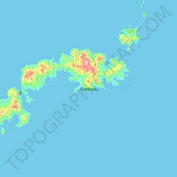
Name: Kadavu topographic map, elevation, terrain.
Location: Kadavu, Eastern, Fiji (-19.16413 177.95177 -18.93130 178.48583)
Average elevation: 17 m
Minimum elevation: -2 m
Maximum elevation: 605 m
Other topographic maps
Click on a map to view its topography, its elevation and its terrain.