
Choiseul topographic map
Interactive map
Click on the map to display elevation.
About this map
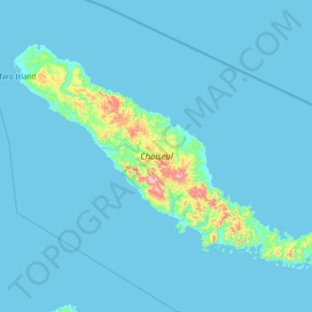
Name: Choiseul topographic map, elevation, terrain.
Location: Choiseul, Choiseul Province, Solomon Islands (-7.42917 156.38557 -6.58917 157.56333)
Average elevation: 38 m
Minimum elevation: -1 m
Maximum elevation: 944 m
Other topographic maps
Click on a map to view its topography, its elevation and its terrain.
Choiseul Province
Solomon Islands > Choiseul Province
Choiseul Province, Solomon Islands
Average elevation: 19 m
Taro Island
Solomon Islands > Choiseul Province > Taro Island
Taro Island, Choiseul Province, Solomon Islands
Average elevation: 1 m