
Mechi topographic map
Interactive map
Click on the map to display elevation.
About this map
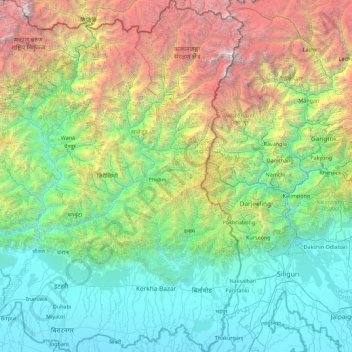
Name: Mechi topographic map, elevation, terrain.
Location: Mechi, Eastern Development Region, Nepal (26.36103 87.44430 27.95305 88.20153)
Average elevation: 1,902 m
Minimum elevation: 59 m
Maximum elevation: 8,411 m
Other topographic maps
Click on a map to view its topography, its elevation and its terrain.
Mount Everest
Nepal > Eastern Development Region > Tashi Dzom > Khumjung
Mount Everest, Khumjung, Solukhumbu, Sagarmatha, Eastern Development Region, Nepal
Average elevation: 7,841 m
Asmit’s Palace
Nepal > Eastern Development Region > Dharan Sub-Metropolitan
Asmit’s Palace, Bhanu Marg, Dhruba Jyori Chowk, Dharan, Dharan Sub-Metropolitan, Sunsari, Koshi, Eastern Development Region, 56100, Nepal
Average elevation: 380 m
Lobuche
Nepal > Eastern Development Region > Khumjung
Lobuche, Khumjung, Solukhumbu, Sagarmatha, Eastern Development Region, 4, Nepal
Average elevation: 4,825 m
Ngozumpa Glacier
Nepal > Eastern Development Region > Khumjung > Khumjung
Ngozumpa Glacier, Khumjung, Solukhumbu, Sagarmatha, Eastern Development Region, Nepal
Average elevation: 5,632 m
Koshi
Nepal > Eastern Development Region
Koshi, Eastern Development Region, Nepal
Average elevation: 1,899 m
Lhotse Shar
Nepal > Eastern Development Region > Khumjung
Lhotse Shar, Khumjung, Solukhumbu, Sagarmatha, Eastern Development Region, Nepal
Average elevation: 7,153 m
Boya
Nepal > Eastern Development Region > Boya
Boya, Bhojpur, Koshi, Eastern Development Region, Nepal
Average elevation: 1,448 m
Morang
Nepal > Eastern Development Region
Morang, Koshi, Eastern Development Region, Nepal
Average elevation: 262 m