
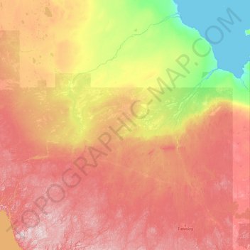
Unorganized North Cochrane topographic map
Interactive map
Click on the map to display elevation.
About this map
Name: Unorganized North Cochrane topographic map, elevation, terrain.
Average elevation: 195 m
Minimum elevation: -2 m
Maximum elevation: 590 m
Other topographic maps
Click on a map to view its topography, its elevation and its terrain.
Sturgeon Falls
Canada > Ontario > Unorganized North Cochrane
Sturgeon Falls, Unorganized North Cochrane, Cochrane District, Northeastern Ontario, Ontario, P5N 1L5, Canada
Average elevation: 215 m