
Sedgwick County topographic map
Interactive map
Click on the map to display elevation.
About this map
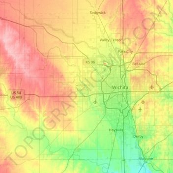
Name: Sedgwick County topographic map, elevation, terrain.
Location: Sedgwick County, Kansas, United States (37.47464 -97.80747 37.91282 -97.15142)
Average elevation: 418 m
Minimum elevation: 368 m
Maximum elevation: 482 m
Other topographic maps
Click on a map to view its topography, its elevation and its terrain.
Mount Hope
United States > Kansas > Sedgwick County
Mount Hope, Sedgwick County, Kansas, United States
Average elevation: 439 m
Bentley
United States > Kansas > Sedgwick County
Bentley, Sedgwick County, Kansas, United States
Average elevation: 424 m
Goddard
United States > Kansas > Sedgwick County > Goddard
Goddard, Sedgwick County, Kansas, United States
Average elevation: 443 m
Wichita
United States > Kansas > Sedgwick County
Wichita, Sedgwick County, Kansas, United States
Average elevation: 408 m