
Walloon Brabant topographic map
Interactive map
Click on the map to display elevation.
About this map
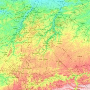
Name: Walloon Brabant topographic map, elevation, terrain.
Location: Walloon Brabant, Wallonia, Belgium (50.52541 4.09178 50.80723 5.02049)
Average elevation: 106 m
Minimum elevation: 5 m
Maximum elevation: 284 m
Other topographic maps
Click on a map to view its topography, its elevation and its terrain.
Orp-le-Grand
Belgium > Walloon Brabant > Nivelles > Orp-le-Grand
Orp-le-Grand, Orp-Jauche, Nivelles, Walloon Brabant, Wallonia, 1350, Belgium
Average elevation: 90 m
Waterloo
Belgium > Walloon Brabant > Nivelles > Waterloo
Waterloo, Nivelles, Walloon Brabant, Wallonia, 1410, Belgium
Average elevation: 112 m