
XII. topographic map
Interactive map
Click on the map to display elevation.
About this map
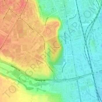
Name: XII. topographic map, elevation, terrain.
Average elevation: 218 m
Minimum elevation: 195 m
Maximum elevation: 246 m
Other topographic maps
Click on a map to view its topography, its elevation and its terrain.
Bezirk Kaschau IV
Slowakei > Kaschauer Landschaftsverband > Bezirk Kaschau IV
Bezirk Kaschau IV, Kaschau, Kaschauer Landschaftsverband, Ostslowakei, Slowakei
Average elevation: 223 m
Barca
Slowakei > Kaschauer Landschaftsverband > Bezirk Kaschau IV
Barca, Košice - mestská časť Barca, Bezirk Kaschau IV, Kaschau, Kaschauer Landschaftsverband, Ostslowakei, Slowakei
Average elevation: 218 m