
Strovolos topographic map
Interactive map
Click on the map to display elevation.
About this map
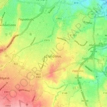
Name: Strovolos topographic map, elevation, terrain.
Location: Strovolos, Nicosia, Nicosia District, Cyprus (35.10305 33.30970 35.16547 33.38176)
Average elevation: 189 m
Minimum elevation: 142 m
Maximum elevation: 238 m
Other topographic maps
Click on a map to view its topography, its elevation and its terrain.
Pano Platres
Cyprus > Cyprus > Pano Platres
Pano Platres, Limassol, Cyprus, 4820, Cyprus
Average elevation: 1,141 m