
Rayong topographic map
Interactive map
Click on the map to display elevation.
About this map
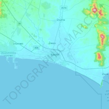
Name: Rayong topographic map, elevation, terrain.
Location: Rayong, Rayong Province, 21000, Thailand (12.52179 101.11777 12.84179 101.43777)
Average elevation: 31 m
Minimum elevation: -3 m
Maximum elevation: 687 m
Other topographic maps
Click on a map to view its topography, its elevation and its terrain.
Map Ta Phut
Thailand > Rayong Province > Rayong > Map Ta Phut > Ban Map Ta Phut
Map Ta Phut, Rayong, Rayong Province, 21150, Thailand
Average elevation: 26 m