
Robeson County topographic map
Interactive map
Click on the map to display elevation.
About this map
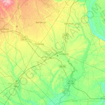
Name: Robeson County topographic map, elevation, terrain.
Location: Robeson County, North Carolina, United States (34.29934 -79.46151 34.95272 -78.80543)
Average elevation: 44 m
Minimum elevation: 10 m
Maximum elevation: 120 m
The topography is mostly level to undulating coastal plain, largely made up of sandhills and coastal dunes with elevations above mean sea level that vary from 60 feet in the extreme southeastern portion of the county to 250 feet in the north, to the west of Parkton, North Carolina. Moreover, numerous swamps that generally flow in a northwest to southeast course, characterize the area and eventually drain into the Lumber River. The highest density of swamps is in that part of the county that is most populated by the Lumbee Tribe of North Carolina, a state recognized tribe.