
Toblacher See topographic map
Interactive map
Click on the map to display elevation.
About this map
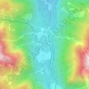
Name: Toblacher See topographic map, elevation, terrain.
Average elevation: 1,520 m
Minimum elevation: 1,212 m
Maximum elevation: 2,132 m
Der Toblacher See (italienisch Lago di Dobbiaco) ist ein kleiner, ursprünglich zerklüfteter Alpensee, der im Höhlensteintal in 1259 m Höhe in der Südtiroler Gemeinde Toblach liegt. Die Rienz ist sein Zu- und Abfluss. Der See hat einen Umfang von etwa 4,5 Kilometern, sein Volumen wird auf 286.000 Kubikmeter geschätzt. Er befindet sich im Naturpark Fanes-Sennes-Prags und ist als Naturdenkmal geschützt.
Other topographic maps
Click on a map to view its topography, its elevation and its terrain.
Blankenstein
Italien > Trentino-Südtirol > Bozen > Toblach
Blankenstein, Toblach, Pustertal, Bozen, Trentino-Südtirol, Italien
Average elevation: 2,221 m
Schlichten
Italien > Trentino-Südtirol > Bozen > Toblach
Schlichten, Toblach, Pustertal, Bozen, Trentino-Südtirol, 39038, Italien
Average elevation: 2,161 m