
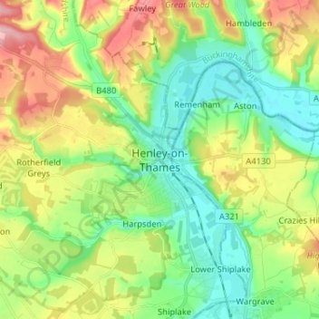
Henley-on-Thames topographic map
Interactive map
Click on the map to display elevation.
About this map
Name: Henley-on-Thames topographic map, elevation, terrain.
Average elevation: 78 m
Minimum elevation: 26 m
Maximum elevation: 169 m
Other topographic maps
Click on a map to view its topography, its elevation and its terrain.
Culham
United Kingdom > England > Oxfordshire > South Oxfordshire
Culham, South Oxfordshire, Oxfordshire, England, United Kingdom
Average elevation: 56 m
Ochre Pits
United Kingdom > England > Oxfordshire > South Oxfordshire > Horspath
Ochre Pits, Forest Hill with Shotover, Horspath, South Oxfordshire, Oxfordshire, South East England, England, United Kingdom
Average elevation: 114 m
Berrick Salome
United Kingdom > England > Oxfordshire > South Oxfordshire > Berrick Salome
Berrick Salome, South Oxfordshire, Oxfordshire, South East England, England, United Kingdom
Average elevation: 61 m