
Bolzano - Bozen topographic map
Interactive map
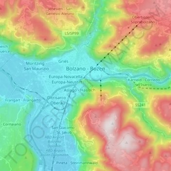
Click on the map to display elevation.
About this map
Name: Bolzano - Bozen topographic map, elevation, terrain.
Average elevation: 716 m
Minimum elevation: 221 m
Maximum elevation: 1,613 m
The area of the city of Bolzano is 52.3 km2 (20.2 sq mi), of which 28 km2 (11 sq mi) is used as a settlement area. The city is located in the basin where the Sarntal, Eisacktal, and the Adige Valley with their rivers, Talfer, Eisack, and Adige, meet. In the Middle Ages, the two main Alpine crossings, the Via Claudia Augusta over Reschenpass and the Brenner route over Brenner Pass, met in Bolzano. Thus, the city was very important for trading. The highest point is 1,616 metres (5,302 feet) above sea level and the lowest point is 232 metres (761 feet) above sea level. The center is located at an altitude of 262 metres (860 feet) above sea level. The nearest big cities are 58 km (36 mi) (Trento) and 118 km (73 mi) (Innsbruck) away.
Other topographic maps
Click on a map to view its topography, its elevation and its terrain.
Muls
Italy > Trentino-Alto Adige/Südtirol > South Tyrol > Sarntal - Sarentino
Muls, Sarntal - Sarentino, Salten-Schlern - Salto-Sciliar, South Tyrol, Trentino-Alto Adige/Südtirol, Italy
Average elevation: 1,678 m
Laimburg - Castel Varco
Italy > Trentino-Alto Adige/Südtirol > South Tyrol > Vadena - Pfatten
Laimburg - Castel Varco, LS/SP162, Kreithof - Maso Kreit, Vadena - Pfatten, Überetsch-Unterland - Oltradige-Bassa Atesina, South Tyrol, Trentino-Alto Adige/Südtirol, 39051, Italy
Average elevation: 321 m
Vetzan - Vezzano
Italy > Trentino-Alto Adige/Südtirol > South Tyrol > Schlanders - Silandro
Vetzan - Vezzano, Schlanders - Silandro, Vinschgau - Val Venosta, South Tyrol, Trentino-Alto Adige/Südtirol, 39028, Italy
Average elevation: 978 m
Kortsch - Corzes
Italy > Trentino-Alto Adige/Südtirol > South Tyrol
Kortsch - Corzes, Schlanders - Silandro, Vinschgau - Val Venosta, South Tyrol, Trentino-Alto Adige/Südtirol, 39028, Italy
Average elevation: 1,067 m
Schlanders - Silandro
Italy > Trentino-Alto Adige/Südtirol > South Tyrol
Schlanders - Silandro, Vinschgau - Val Venosta, South Tyrol, Trentino-Alto Adige/Südtirol, 39028, Italy
Average elevation: 1,912 m
Urtijëi - St. Ulrich in Gröden - Ortisei
Italy > Trentino-Alto Adige/Südtirol > South Tyrol
Urtijëi - St. Ulrich in Gröden - Ortisei, Salten-Schlern - Salto-Sciliar, South Tyrol, Trentino-Alto Adige/Südtirol, 39046, Italy
Average elevation: 1,688 m
Ulten - Ultimo
Italy > Trentino-Alto Adige/Südtirol > South Tyrol
Ulten - Ultimo, Burggrafenamt - Burgraviato, South Tyrol, Trentino-Alto Adige/Südtirol, 39016, Italy
Average elevation: 2,003 m