
Galicia topographic map
Interactive map
Click on the map to display elevation.
About this map
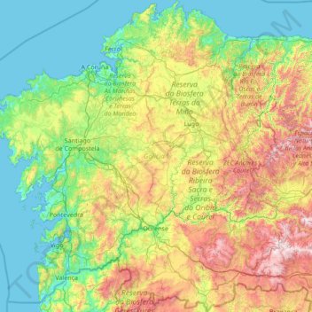
Name: Galicia topographic map, elevation, terrain.
Location: Galicia, Spain (41.80736 -9.30154 43.79042 -6.73395)
Average elevation: 456 m
Minimum elevation: -2 m
Maximum elevation: 2,088 m
The interior of Galicia is characterized by a hilly landscape; mountain ranges rise to 2,000 m (6,600 ft) in the east and south. The coastal areas are mostly an alternate series of rias and beaches. The climate of Galicia is usually temperate and rainy, with markedly drier summers; it is usually classified as Oceanic. Its topographic and climatic conditions have made animal husbandry and farming the primary source of Galicia's wealth for most of its history, allowing for a relatively high density of population. Except shipbuilding and food processing, Galicia was based on a farming and fishing economy until after the mid-20th century, when it began to industrialize. In 2018, the nominal gross domestic product was €62.900 billion, with a nominal GDP per capita of €23,300. Galicia is characterised, unlike other Spanish regions, by the absence of a metropolis dominating the territory. Indeed, the urban network is made up of 7 main cities (the four provincial capitals A Coruña, Pontevedra, Ourense and Lugo, the political capital Santiago de Compostela and the industrial cities Vigo and Ferrol and other small towns. The population is largely concentrated in two main areas: from Ferrol to A Coruña on the northern coast, and in the Rías Baixas region in the southwest, including the cities of Vigo, Pontevedra, and the interior city of Santiago de Compostela. There are smaller populations around the interior cities of Lugo and Ourense. The political capital is Santiago de Compostela, in the province of A Coruña. Vigo, in the province of Pontevedra, is the largest municipality in Galicia and also the most populated city. Two languages are official and widely used today in Galicia: the native Galician, a Romance language closely related to Portuguese with which it shares the Galician-Portuguese medieval literature; and Spanish, usually called Castilian. While most Galicians are bilingual, a 2013 survey reported that 51% of the Galician population spoke Galician most often on a day-to-day basis, while 48% most often used Spanish.
Other topographic maps
Click on a map to view its topography, its elevation and its terrain.
Barcelona
Spain > Catalonia > Barcelonès
Barcelona, Barcelonès, Barcelona, Catalonia, 08001, Spain
Average elevation: 65 m
Málaga
Spain > Andalusia > Málaga-Costa del Sol
Málaga, Málaga-Costa del Sol, Malaga, Andalusia, Spain
Average elevation: 276 m
Oiartzabal
Spain > Iruñerria / Comarca de Pamplona > Anue
Oiartzabal, Anue, Iruñerria / Comarca de Pamplona, Spain
Average elevation: 835 m
Campillos
Spain > Andalusia > Guadalteba
Campillos, Guadalteba, Malaga, Andalusia, 29320, Spain
Average elevation: 476 m
Granada
Spain > Andalusia > Comarca de la Vega de Granada
Granada, Comarca de la Vega de Granada, Granada, Andalusia, Spain
Average elevation: 829 m
Arriondas / Les Arriondes
Arriondas / Les Arriondes, Parres, Asturias, 33540, Spain
Average elevation: 187 m
Los Laganes
Spain > Andalusia > La Janda > Alcalá de los Gazules
Los Laganes, Alcalá de los Gazules, La Janda, Cádiz, Andalusia, Spain
Average elevation: 234 m
Urbanización Palacio de Meres - Fontemera
Urbanización Palacio de Meres - Fontemera, Siero, Asturias, 33199, Spain
Average elevation: 208 m
Alicante
Alicante, l'Alacantí, Alacant / Alicante, Valencian Community, Spain
Average elevation: 143 m
Las Casicas
Spain > Andalusia > Valle del Almanzora > Almanzora
Las Casicas, Almanzora, Cantoria, Valle del Almanzora, Almeria, Andalusia, 04815, Spain
Average elevation: 347 m
Almanzora
Spain > Andalusia > Valle del Almanzora
Almanzora, Cantoria, Valle del Almanzora, Almeria, Andalusia, 04815, Spain
Average elevation: 369 m
Hondarribia
Spain > Autonomous Community of the Basque Country > Bidasoa Beherea / Bajo Bidasoa
Hondarribia, Bidasoa Beherea / Bajo Bidasoa, Gipuzkoa, Autonomous Community of the Basque Country, 20280, Spain
Average elevation: 37 m
La Hoya
Spain > Andalusia > Valle del Almanzora > Arboleas
La Hoya, Arboleas, Valle del Almanzora, Almeria, Andalusia, Spain
Average elevation: 538 m
Badajoz
Spain > Extremadura > Tierra de Badajoz
Badajoz, Tierra de Badajoz, Badajoz, Extremadura, Spain
Average elevation: 261 m
La Hoya
La Hoya, Salamanca, Castile and León, Spain
Average elevation: 1,401 m
Valldemossa
Spain > Balearic Islands > Serra de Tramuntana
Valldemossa, Serra de Tramuntana, Balearic Islands, 07170, Spain
Average elevation: 360 m
Palas de Rei
Palas de Rei, A Ulloa, Lugo, Galicia, Spain
Average elevation: 559 m
Montferrer
Spain > Catalonia > Alt Urgell > Montferrer i Castellbò
Montferrer, Montferrer i Castellbò, Alt Urgell, Catalonia, 25711, Spain
Average elevation: 755 m
Mar Menor
Spain > Campo de Cartagena y Mar Menor
Mar Menor, Campo de Cartagena y Mar Menor, 30730, Spain
Average elevation: 11 m
La Puente
La Puente, La Orotava, Santa Cruz de Tenerife, Canary Islands, 38410, Spain
Average elevation: 407 m
Cortes
Spain > Navarre > Erribera / Ribera
Cortes, Erribera / Ribera, Navarre, 31530, Spain
Average elevation: 261 m
El Reventado
Spain > Castile and León > Fontiveros
El Reventado, Fontiveros, Ávila, Castile and León, 05309, Spain
Average elevation: 917 m
Melide
Spain > Galicia > Terra de Melide
Melide, Terra de Melide, A Coruña, Galicia, Spain
Average elevation: 504 m
San Sebastián de Garabandal
San Sebastián de Garabandal, Rionansa, Cantabria, 39554, Spain
Average elevation: 671 m