
New Delhi topographic map
Interactive map
Click on the map to display elevation.
About this map
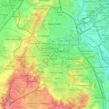
Name: New Delhi topographic map, elevation, terrain.
Location: New Delhi, Delhi, India (28.48126 77.05037 28.64568 77.25514)
Average elevation: 230 m
Minimum elevation: 193 m
Maximum elevation: 290 m
With a total area of 42.7 km2 (16.5 sq mi), New Delhi forms a small part of the Delhi metropolitan area. Since the city is located on the Indo-Gangetic Plain, there is little difference in elevation across the city. New Delhi and surrounding areas were once a part of the Aravali Range; all that is left of those mountains is the Delhi Ridge, which is also called the Lungs of Delhi. While New Delhi lies on the floodplains of the Yamuna River, it is essentially a landlocked city. East of the river is the urban area of Shahdara. New Delhi falls under the seismic zone-IV, making it vulnerable to earthquakes.
Other topographic maps
Click on a map to view its topography, its elevation and its terrain.
Delhi
India > Delhi > Kotwali Tehsil
Delhi, Kotwali Tehsil, Central Delhi, Delhi, 110006, India
Average elevation: 216 m