
Newark topographic map
Interactive map
Click on the map to display elevation.
About this map
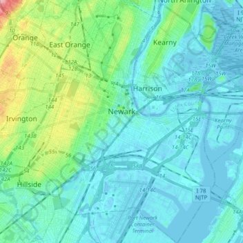
Name: Newark topographic map, elevation, terrain.
Location: Newark, Essex County, New Jersey, United States (40.67325 -74.25133 40.78814 -74.11418)
Average elevation: 22 m
Minimum elevation: -11 m
Maximum elevation: 131 m
According to the United States Census Bureau, the city had a total area of 25.89 square miles (67.1 km2), including 24.14 square miles (62.5 km2) of land and 1.74 square miles (4.5 km2) of water (6.72%). It has the third-smallest land area among the 100 most populous cities in the U.S., behind neighboring Jersey City and Hialeah, Florida. The city's altitude ranges from 0 (sea level) in the east to approximately 230 feet (70 m) above sea level in the western section of the city. Newark is essentially a large basin sloping towards the Passaic River, with a few valleys formed by meandering streams. Historically, Newark's high places have been its wealthier neighborhoods. In the 19th century and early 20th century, the wealthy congregated on the ridges of Forest Hill, High Street, and Weequahic.
Other topographic maps
Click on a map to view its topography, its elevation and its terrain.
East Orange
United States > New Jersey > Essex County
East Orange, Essex County, New Jersey, United States
Average elevation: 49 m
Livingston
United States > New Jersey > Essex County
Livingston, Essex County, New Jersey, 07039, United States
Average elevation: 104 m
Short Hills
United States > New Jersey > Essex County > Millburn > Short Hills
Short Hills, Millburn, Essex County, New Jersey, 07078, United States
Average elevation: 98 m