
Hallstatt topographic map
Interactive map
Click on the map to display elevation.
About this map
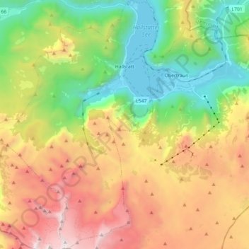
Name: Hallstatt topographic map, elevation, terrain.
Location: Hallstatt, Bezirk Gmunden, Upper Austria, 4830, Austria (47.47499 13.55157 47.59373 13.67212)
Average elevation: 1,515 m
Minimum elevation: 501 m
Maximum elevation: 2,903 m
The Hallstatt salt mine is the world's oldest working salt mine. The mine is located within the Upper Permian to Lower Triassic Haselgebirge Formation of the Northern Limestone Alps. The Hallstatt salt mine comprises 21 levels and several smaller shafts ranging from 514 m above sea level (Erbstollen level) to an elevation of around 1267 m (Erzherzog Matthias Schurf level).
Other topographic maps
Click on a map to view its topography, its elevation and its terrain.
Reiterndorf
Austria > Upper Austria > Bezirk Gmunden > Bad Ischl
Reiterndorf, Bad Ischl, Bezirk Gmunden, Upper Austria, 4820, Austria
Average elevation: 601 m
Loser
Austria > Upper Austria > Bezirk Gmunden > Ebensee
Loser, Ebensee, Bezirk Gmunden, Upper Austria, 4802, Austria
Average elevation: 709 m