
Sarawak topographic map
Interactive map
Click on the map to display elevation.
About this map
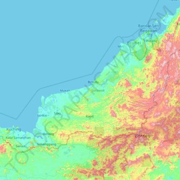
Name: Sarawak topographic map, elevation, terrain.
Location: Sarawak, Malaysia (0.85382 109.53804 5.10833 115.67803)
Average elevation: 228 m
Minimum elevation: -4 m
Maximum elevation: 2,148 m
Sarawak can be divided into two geological zones: the Sunda Shield, which extends southwest from the Batang Lupar River (near Sri Aman) and forms the southern tip of Sarawak, and the geosyncline region, which extends northeast to the Batang Lupar River, forming the central and northern regions of Sarawak. The oldest rock type in southern Sarawak is schist formed during the Carboniferous and Lower Permian times, while the youngest igneous rock in this region, andesite, can be found at Sematan. Geological formation of the central and northern regions started during the late Cretaceous period. Other types of stone that can be found in central and northern Sarawak are shale, sandstone, and chert. The Miri Division in eastern Sarawak is the region of Neogene strata containing organic rich rock formations which are the prolific oil and gas reserves. The rocks enriched in organic components are mudstones in Lambir, Miri and Tukau Formations of Middle Miocene-Lower Pliocene age. Significant quantities of Sarawak soil are lithosols, up to 60 per cent, and podsols, around 12 per cent, while abundant alluvial soil is found in coastal and riverine regions. 12 per cent of Sarawak is covered with peat swamp forest. Limestone with well-developed karst topography and cave systems is found scattered from west to east Sarawak, but concentrated in certain regions such as in the Bau district in the west and southwards near the Kalimantan border.
Other topographic maps
Click on a map to view its topography, its elevation and its terrain.
Semenyih
Malaysia > Kajang Municipal Council
Semenyih, Kajang Municipal Council, Hulu Langat, Selangor, 43500, Malaysia
Average elevation: 62 m
Cameron Highlands
Cameron Highlands, Pahang, 39000, Malaysia
Average elevation: 1,400 m
Johor Bahru
Johor Bahru, Iskandar Malaysia, Johor, 80350, Malaysia
Average elevation: 28 m
Sarawak River
Sarawak River, Kuching, Kuching Division, Sarawak, 93XXX, Malaysia
Average elevation: 6 m
Genting Highlands
Genting Highlands, Bentong, Pahang, 69000, Malaysia
Average elevation: 1,141 m
Kampung Anjung Batu
Kampung Anjung Batu, Tangkak, Johor, 84900, Malaysia
Average elevation: 16 m
PJU 8
Malaysia > Selangor > Petaling Jaya
PJU 8, Petaling Jaya, Petaling, Selangor, Malaysia
Average elevation: 103 m
Kampung Lui Muda
Kampung Lui Muda, Jempol, Negeri Sembilan, Malaysia
Average elevation: 118 m
Kampung Air Merah
Kampung Air Merah, Mersing, Johor, 86800, Malaysia
Average elevation: 10 m
Seremban
Seremban, Negeri Sembilan, 70000, Malaysia
Average elevation: 168 m
Kampung Padang Serai
Malaysia > Kedah > Pokok Sena
Kampung Padang Serai, Pokok Sena, Kedah, 06400, Malaysia
Average elevation: 23 m
Bukit Terbakar
Malaysia > Malacca > Alor Gajah
Bukit Terbakar, Alor Gajah, Malacca, 76000, Malaysia
Average elevation: 56 m
Bukit Banang
Malaysia > Johor > Batu Pahat
Bukit Banang, Batu Pahat, Johor, 83000, Malaysia
Average elevation: 155 m
Puchong
Malaysia > Selangor > Subang Jaya
Puchong, Subang Jaya, Petaling, Selangor, 47160, Malaysia
Average elevation: 38 m
Kampung Sungai Balak
Malaysia > Selangor > Kajang Municipal Council
Kampung Sungai Balak, Kajang Municipal Council, Hulu Langat, Selangor, Malaysia
Average elevation: 38 m
Subang Jaya
Malaysia > Selangor > Subang Jaya
Subang Jaya, Selangor, 47610, Malaysia
Average elevation: 35 m
Seri Iskandar
Seri Iskandar, Perak Tengah, Perak, 32610, Malaysia
Average elevation: 29 m
Kampung Ketek
Malaysia > Malacca > Malacca City
Kampung Ketek, Malacca City, Central Malacca, Malacca, 75100, Malaysia
Average elevation: 5 m
Kampung Jeram Pantai
Kampung Jeram Pantai, Jeram, Kuala Selangor, Selangor, 45800, Malaysia
Average elevation: 2 m
Kampung Ulu Bendul
Kampung Ulu Bendul, Kuala Pilah, Negeri Sembilan, Malaysia
Average elevation: 326 m
Kampung Kenanga
Malaysia > Selayang Municipal Council > Rawang
Kampung Kenanga, Rawang, Selayang Municipal Council, Gombak, 48000, Malaysia
Average elevation: 62 m