
Chattahoochee Bend State Park topographic map
Interactive map
Click on the map to display elevation.
About this map
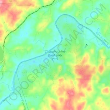
Name: Chattahoochee Bend State Park topographic map, elevation, terrain.
Location: Chattahoochee Bend State Park, Coweta County, Georgia, USA (33.41302 -85.01756 33.45695 -84.94470)
Average elevation: 238 m
Minimum elevation: 202 m
Maximum elevation: 303 m
Other topographic maps
Click on a map to view its topography, its elevation and its terrain.
Orange Springs
USA > Georgia > Orange Springs
Orange Springs, Grady County, Georgia, 31797, USA
Average elevation: 78 m
Cameron Point
USA > Georgia > Cameron Point
Cameron Point, Hall County, Georgia, 30506:30534, USA
Average elevation: 339 m
Forbes Lake
USA > Georgia > Saint Louis
Forbes Lake, Dandelion Drive, Saint Louis, Macon County, Georgia, USA
Average elevation: 126 m
Sandy Springs
USA > Georgia > Sandy Springs
Sandy Springs, Fulton County, Georgia, USA
Average elevation: 301 m
Ferrell Crossroads
USA > Georgia > Ferrell Crossroads
Ferrell Crossroads, Early County, Georgia, USA
Average elevation: 94 m