
Kilsyth topographic map
Interactive map
Click on the map to display elevation.
About this map
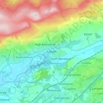
Name: Kilsyth topographic map, elevation, terrain.
Location: Kilsyth, North Lanarkshire, Scotland, G65 0AQ, United Kingdom (55.93654 -4.09597 56.01654 -4.01597)
Average elevation: 161 m
Minimum elevation: 34 m
Maximum elevation: 462 m
The civil war Battle of Kilsyth took place on hillsides between Kilsyth and Banton in 1645. Kilsyth was later closely associated with the various attempts by the Jacobites to regain the crown. Bonnie Prince Charlie is reported to have spent the night in the town in January 1746. The battlefield is now under the Townhead Reservoir (Banton Loch) which is a largely artificial body of water used to feed the Forth and Clyde Canal, close to its highest elevation. The canal was cut through Dullatur Bog in 1769-1770 bringing economic benefit to Kilsyth. (It apparently disturbed many small toads which relocated by hopping northwards).
Other topographic maps
Click on a map to view its topography, its elevation and its terrain.
Cumbernauld
United Kingdom > Scotland > North Lanarkshire
Cumbernauld, North Lanarkshire, Scotland, United Kingdom
Average elevation: 113 m
Cumbernauld
United Kingdom > Scotland > North Lanarkshire > Cumbernauld
Cumbernauld, North Lanarkshire, Scotland, G67 1NG, United Kingdom
Average elevation: 111 m
Shotts
United Kingdom > Scotland > North Lanarkshire
Shotts, North Lanarkshire, Scotland, ML7 4AW, United Kingdom
Average elevation: 231 m