
Kisoro topographic map
Interactive map
Click on the map to display elevation.
About this map
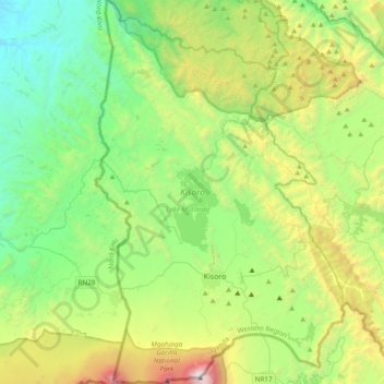
Name: Kisoro topographic map, elevation, terrain.
Location: Kisoro, Western Region, Uganda (-1.38942 29.57343 -1.00664 29.82131)
Average elevation: 1,943 m
Minimum elevation: 1,069 m
Maximum elevation: 4,084 m
Other topographic maps
Click on a map to view its topography, its elevation and its terrain.
Kyaka II Refugee Settlement
Uganda > Kyegegwa > Byabakora Ii
Kyaka II Refugee Settlement, Byabakora Ii, Kyegegwa, Western Region, Uganda
Average elevation: 1,290 m
Isreal-matovu
Uganda > Central Region > Kampala
Isreal-matovu, Kampala, Central Region, Uganda
Average elevation: 1,187 m
Fort Portal City
Fort Portal City, Bunyangabu, Western Region, Uganda
Average elevation: 1,525 m
Bombo
Uganda > Bulambuli > Bugisa sub-region
Bombo, Bugisa sub-region, Bulambuli, Eastern Region, Uganda
Average elevation: 2,022 m
Water
Uganda > Wakiso > Entebbe City
Water, Entebbe City, Wakiso, Central Region, Uganda
Average elevation: 1,134 m