
Freshwater topographic map
Interactive map
Click on the map to display elevation.
About this map
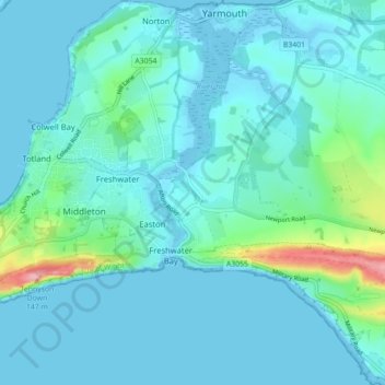
Name: Freshwater topographic map, elevation, terrain.
Location: Freshwater, Isle of Wight, England, United Kingdom (50.65151 -1.53881 50.70734 -1.46059)
Average elevation: 19 m
Minimum elevation: -4 m
Maximum elevation: 145 m
Other topographic maps
Click on a map to view its topography, its elevation and its terrain.
Chessell
United Kingdom > England > Isle of Wight
Chessell, Calbourne, Isle of Wight, England, PO41 0UD, United Kingdom
Average elevation: 69 m
Sandown
United Kingdom > England > Isle of Wight
Sandown, Isle of Wight, England, United Kingdom
Average elevation: 18 m
Ryde
United Kingdom > England > Isle of Wight
Ryde, Isle of Wight, England, United Kingdom
Average elevation: 21 m