
Poynton topographic map
Interactive map
Click on the map to display elevation.
About this map
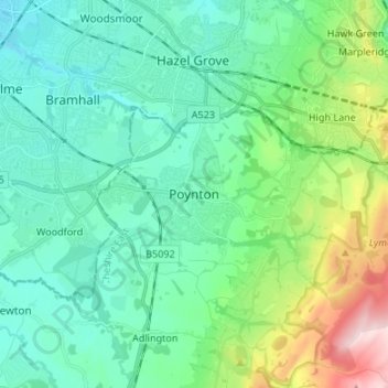
Name: Poynton topographic map, elevation, terrain.
Location: Poynton, Cheshire East, England, SK12 1GP, United Kingdom (53.30925 -2.15744 53.38925 -2.07744)
Average elevation: 130 m
Minimum elevation: 56 m
Maximum elevation: 383 m
Other topographic maps
Click on a map to view its topography, its elevation and its terrain.
Goostrey
United Kingdom > England > Cheshire East
Goostrey, Cheshire East, England, United Kingdom
Average elevation: 67 m
Thurlwood
United Kingdom > England > Cheshire East
Thurlwood, Cheshire East, England, ST7 3TJ, United Kingdom
Average elevation: 91 m
Wilmslow
United Kingdom > England > Cheshire East > Wilmslow
Wilmslow, Cheshire East, North West England, England, United Kingdom
Average elevation: 83 m
Macclesfield
United Kingdom > England > Cheshire East
Macclesfield, Cheshire East, England, United Kingdom
Average elevation: 182 m