
Lake Mweru topographic map
Interactive map
Click on the map to display elevation.
About this map
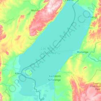
Name: Lake Mweru topographic map, elevation, terrain.
Location: Lake Mweru, Luapula Province, Zambia (-9.58023 28.32181 -8.47772 29.15652)
Average elevation: 1,022 m
Minimum elevation: 915 m
Maximum elevation: 1,483 m
Other topographic maps
Click on a map to view its topography, its elevation and its terrain.
Mansa
Mansa, Mansa District, Luapula Province, Zambia
Average elevation: 1,218 m