
Ariel Sharon park topographic map
Interactive map
Click on the map to display elevation.
About this map
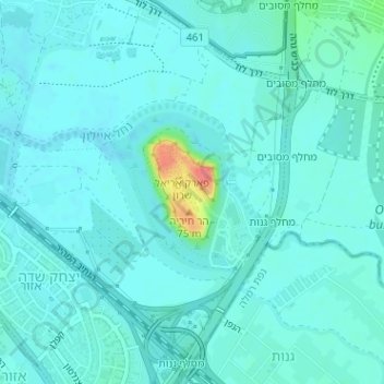
Name: Ariel Sharon park topographic map, elevation, terrain.
Location: Ariel Sharon park, Yitzhak Sade, Tel Aviv District, no, Israel (32.03024 34.82144 32.03034 34.82154)
Average elevation: 26 m
Minimum elevation: 17 m
Maximum elevation: 80 m
Other topographic maps
Click on a map to view its topography, its elevation and its terrain.
Tel Aviv-Yafo
Tel Aviv-Yafo, Tel Aviv Subdistrict, Tel Aviv District, Israel
Average elevation: 17 m
Jaffa
Israel > Tel Aviv District > Tel Aviv-Yafo
Jaffa, Tel Aviv-Yafo, Tel Aviv District, Israel
Average elevation: 12 m
Givatayim
Israel > Tel Aviv District > Givatayim > Givatayim
Givatayim, Tel Aviv District, 53100, Israel
Average elevation: 44 m
Zoological Park
Israel > Tel Aviv District > Tel Aviv-Yafo
Zoological Park, Tel Aviv, Maoz Aviv A, Tel Aviv-Yafo, Tel Aviv District, no, Israel
Average elevation: 22 m