
Charlotte topographic map
Interactive map
Click on the map to display elevation.
About this map
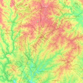
Name: Charlotte topographic map, elevation, terrain.
Location: Charlotte, Mecklenburg County, North Carolina, United States (35.01052 -81.00955 35.40025 -80.63488)
Average elevation: 207 m
Minimum elevation: 152 m
Maximum elevation: 271 m
According to the United States Census Bureau, the city has a total area of 308.6 square miles (799 km2), of which 306.6 square miles (794 km2) is land and 2.0 square miles (5.2 km2) is water.[63] Charlotte is the twenty-sixth-most expansive city in the United States and lies at an elevation of 751 feet (229 m). Charlotte constitutes most of Mecklenburg County in the Carolina Piedmont.[64] Uptown Charlotte sits atop a long rise between two creeks, Sugar Creek and Irwin Creek, and was built on the gunnies of the St. Catherine's and Rudisill gold mines.[65] Charlotte is 25 miles (40 km) southwest of Concord,[66] 26 miles (41 km) northeast of Rock Hill, South Carolina,[67] 83 miles (144 km) southwest of Greensboro,[68] 135 miles (217 km) west of Fayetteville,[69] and 165 miles (265 km) southwest of Raleigh, the state capitol.[70]
Other topographic maps
Click on a map to view its topography, its elevation and its terrain.
Sharonbrook
United States > North Carolina > Mecklenburg County > Charlotte > Sharonbrook
Sharonbrook, Charlotte, Mecklenburg County, North Carolina, 28143, United States
Average elevation: 187 m