
Belair topographic map
Interactive map
Click on the map to display elevation.
About this map
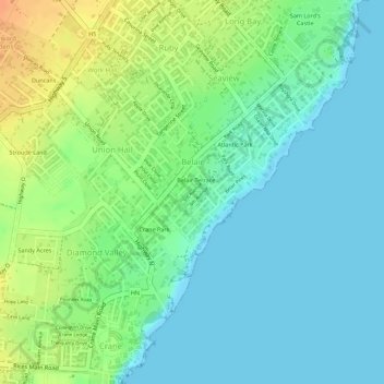
Name: Belair topographic map, elevation, terrain.
Location: Belair, Saint Philip, Barbados (13.11028 -59.44604 13.12184 -59.43562)
Average elevation: 15 m
Minimum elevation: 0 m
Maximum elevation: 41 m
Other topographic maps
Click on a map to view its topography, its elevation and its terrain.
Castle
Barbados > Saint Peter > Diamond Corner
Castle, Diamond Corner, Saint Peter, BB25012, Barbados
Average elevation: 133 m
The Valley
Barbados > Saint George > The Valley
The Valley, Saint George, BB11093, Barbados
Average elevation: 93 m
Graveyard
Barbados > Saint Lucy > Pie Corner > Graveyard
Graveyard, Pie Corner, Saint Lucy, BB25012, Barbados
Average elevation: 69 m