
Dublin topographic map
Interactive map
Click on the map to display elevation.
About this map
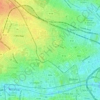
Name: Dublin topographic map, elevation, terrain.
Location: Dublin, County Dublin, Leinster, Ireland (53.35717 -6.27140 53.35735 -6.27101)
Average elevation: 19 m
Minimum elevation: 2 m
Maximum elevation: 42 m
Other topographic maps
Click on a map to view its topography, its elevation and its terrain.
Harmonstown
Harmonstown, Coolock D ED, Dublin, Dublin 5, Leinster, Ireland
Average elevation: 26 m
Botanic Garden
Botanic Garden, Botanic A ED, Dublin, Dublin 9, Leinster, D09 VY63, Ireland
Average elevation: 31 m
North Bull Island
North Bull Island, Raheny St. Assam ED, Dublin 5, Dublin, County Dublin, Leinster, Ireland
Average elevation: 2 m
Beggarsbush
Beggarsbush, Pembroke West A ED, Dublin 4, Dublin, County Dublin, Leinster, Ireland
Average elevation: 7 m