
Servigliano topographic map
Interactive map
Click on the map to display elevation.
About this map
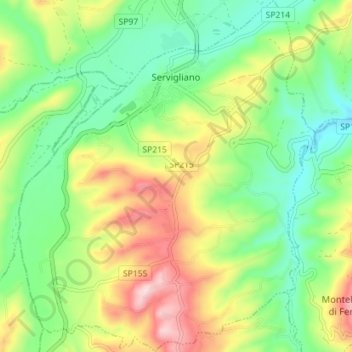
Name: Servigliano topographic map, elevation, terrain.
Location: Servigliano, Fermo, Marche, Italy (43.04108 13.46191 43.09291 13.52184)
Average elevation: 258 m
Minimum elevation: 144 m
Maximum elevation: 443 m
Other topographic maps
Click on a map to view its topography, its elevation and its terrain.
Porto Sant'Elpidio
Porto Sant'Elpidio, Fermo, Marche, 63821, Italy
Average elevation: 24 m