
Aurangabad topographic map
Interactive map
Click on the map to display elevation.
About this map
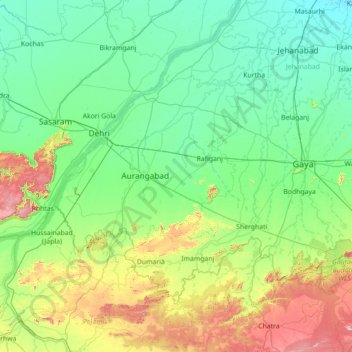
Name: Aurangabad topographic map, elevation, terrain.
Location: Aurangabad, Bihar, India (24.11000 83.86000 25.39000 85.14000)
Average elevation: 166 m
Minimum elevation: 52 m
Maximum elevation: 674 m
Other topographic maps
Click on a map to view its topography, its elevation and its terrain.
Dinapur-Cum-Khagaul
Dinapur-Cum-Khagaul, Patna District, Bihar, India
Average elevation: 51 m
Manikpur
India > Bihar > Narpatganj > Manikpur
Manikpur, Narpatganj, Araria, Bihar, 854336, India
Average elevation: 70 m
Gaya
India > Bihar > Gaya Town C.D.Block > Gaya
Gaya, Gaya Town C.D.Block, Gaya, Bihar, 823001, India
Average elevation: 111 m