
Mount Makalu topographic map
Interactive map
Click on the map to display elevation.
About this map
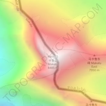
Name: Mount Makalu topographic map, elevation, terrain.
Location: Mount Makalu, Tingri County, Shigatse, Tibet, China (27.89115 87.08859 27.89125 87.08869)
Average elevation: 7,484 m
Minimum elevation: 6,279 m
Maximum elevation: 8,389 m
Other topographic maps
Click on a map to view its topography, its elevation and its terrain.
Ronxar
China > Tibet > Tingri County > Ronxar
Ronxar, Tingri County, Shigatse, Tibet, China
Average elevation: 5,002 m