
Missoula topographic map
Interactive map
Click on the map to display elevation.
About this map
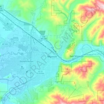
Name: Missoula topographic map, elevation, terrain.
Location: Missoula, Missoula County, Montana, United States (46.79154 -114.12729 46.94995 -113.89732)
Average elevation: 1,173 m
Minimum elevation: 943 m
Maximum elevation: 2,021 m
Other topographic maps
Click on a map to view its topography, its elevation and its terrain.
Pinegrove
United States > Montana > Missoula County > Pinegrove
Pinegrove, Missoula County, Montana, 59851, United States
Average elevation: 1,155 m