
Grant Park topographic map
Interactive map
Click on the map to display elevation.
About this map
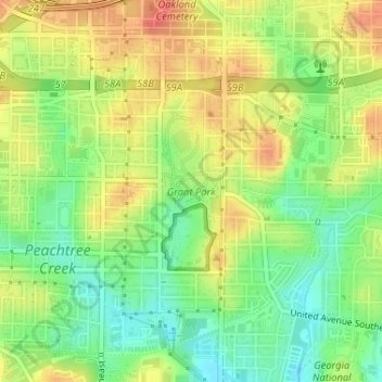
Name: Grant Park topographic map, elevation, terrain.
Average elevation: 298 m
Minimum elevation: 271 m
Maximum elevation: 325 m
Other topographic maps
Click on a map to view its topography, its elevation and its terrain.
Adams Park
United States of America > Georgia > Atlanta > Adams Park
Adams Park, Atlanta, Fulton County, Georgia, 30311, United States of America
Average elevation: 295 m
Vine City
United States of America > Georgia > Atlanta > Vine City
Vine City, Atlanta, Fulton County, Georgia, 30313, United States of America
Average elevation: 301 m
Freedom Park
United States of America > Georgia > Atlanta
Freedom Park, Little Five Points, Atlanta, Fulton County, Georgia, United States of America
Average elevation: 306 m