
Castlereagh topographic map
Interactive map
Click on the map to display elevation.
About this map
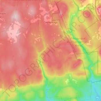
Name: Castlereagh topographic map, elevation, terrain.
Average elevation: 213 m
Minimum elevation: 39 m
Maximum elevation: 333 m
Other topographic maps
Click on a map to view its topography, its elevation and its terrain.
Springside
Canada > Nova Scotia > Municipality of Colchester > Springside
Springside, Eastville, Municipality of Colchester, Colchester County, Nova Scotia, Canada
Average elevation: 93 m
Belmont
Canada > Nova Scotia > Municipality of Colchester > Belmont
Belmont, Municipality of Colchester, Colchester County, Nova Scotia, Canada
Average elevation: 94 m