
Lac du Der-Chantecoq topographic map
Interactive map
Click on the map to display elevation.
About this map
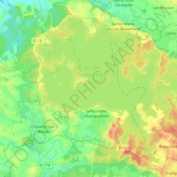
Name: Lac du Der-Chantecoq topographic map, elevation, terrain.
Average elevation: 133 m
Minimum elevation: 110 m
Maximum elevation: 166 m
Other topographic maps
Click on a map to view its topography, its elevation and its terrain.
Les Grandes Côtes
France > Grand Est > Marne > Sainte-Marie-du-Lac-Nuisement
Les Grandes Côtes, Sainte-Marie-du-Lac-Nuisement, Vitry-le-François, Marne, Grand Est, France métropolitaine, 51290, France
Average elevation: 132 m