
Gaviapass topographic map
Interactive map
Click on the map to display elevation.
About this map
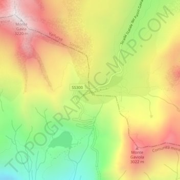
Name: Gaviapass topographic map, elevation, terrain.
Average elevation: 2,659 m
Minimum elevation: 2,124 m
Maximum elevation: 3,172 m
Der Gaviapass liegt im Nationalpark Stilfserjoch und verbindet Bormio im Norden mit Ponte di Legno im Süden über eine 43 km lange Passstraße (SS300, bis April 2021 SP29 in Sondrio, SP BS 300 in Brescia). Auf der Nordrampe sind zehn Kehren bis zur 2621 m s.l.m. hoch gelegenen Passhöhe zu durchfahren, auf der Südrampe fünfzehn Kehren. Der zu überwindende Höhenunterschied beträgt jeweils etwa 1400 m.