
Catania topographic map
Interactive map
Click on the map to display elevation.
About this map
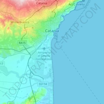
Name: Catania topographic map, elevation, terrain.
Location: Catania, Sicily, Italy (37.35830 14.93587 37.56239 15.12579)
Average elevation: 50 m
Minimum elevation: -1 m
Maximum elevation: 441 m
Around 263 BC, the city was variously known as Catĭna (Latin: [ˈkatɪna]) and Catăna (Latin: [ˈkatana]; Ancient Greek: Κατάνη [katánɛː]). The former has been primarily used for its supposed assonance with catina, the Latin feminization of the name catinus. Catinus has two meanings: "a gulf, a basin or a bay" and "a bowl, a vessel or a trough", thanks to the city's distinctive topography.
Other topographic maps
Click on a map to view its topography, its elevation and its terrain.
Zafferana Etnea
Zafferana Etnea, Catania, Sicily, 95019, Italy
Average elevation: 771 m