
Washington topographic map
Interactive map
Click on the map to display elevation.
About this map
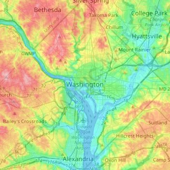
Name: Washington topographic map, elevation, terrain.
Location: Washington, District of Columbia, United States (38.79163 -77.11979 38.99597 -76.90937)
Average elevation: 52 m
Minimum elevation: -3 m
Maximum elevation: 138 m
The highest natural elevation in the district is 409 feet (125 m) above sea level at Fort Reno Park in upper northwest Washington. The lowest point is sea level at the Potomac River. The geographic center of Washington is near the intersection of 4th and L Streets NW.
Other topographic maps
Click on a map to view its topography, its elevation and its terrain.
Ward 7
United States > District of Columbia > Washington
Ward 7, Washington, District of Columbia, 20019, United States
Average elevation: 38 m
Ward 2
United States > District of Columbia > Washington
Ward 2, Washington, District of Columbia, United States
Average elevation: 23 m