
Tathra topographic map
Interactive map
Click on the map to display elevation.
About this map
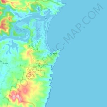
Name: Tathra topographic map, elevation, terrain.
Average elevation: 23 m
Minimum elevation: -4 m
Maximum elevation: 173 m
Other topographic maps
Click on a map to view its topography, its elevation and its terrain.
Bega River
Australia > New South Wales > Tathra > Chinnock
Bega River, Chinnock, Tathra, Bega Valley Shire Council, New South Wales, 2550, Australia
Average elevation: 46 m
Kianinny Bay
Australia > New South Wales > Tathra
Kianinny Bay, Tathra, Bega Valley Shire Council, New South Wales, 2550, Australia
Average elevation: 29 m