
Réservoir de la Mouche topographic map
Interactive map
Click on the map to display elevation.
About this map
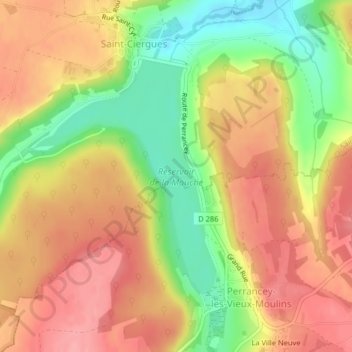
Name: Réservoir de la Mouche topographic map, elevation, terrain.
Average elevation: 397 m
Minimum elevation: 337 m
Maximum elevation: 441 m
Other topographic maps
Click on a map to view its topography, its elevation and its terrain.
Langres
France > Grand Est > Saint-Ciergues
Langres, D 286, Saint-Ciergues, Langres, Haute-Marne, Grand Est, France métropolitaine, 52200, France
Average elevation: 402 m