
Lake Kivu topographic map
Interactive map
Click on the map to display elevation.
About this map
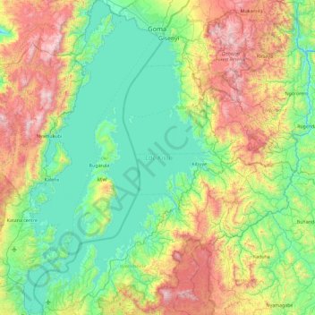
Name: Lake Kivu topographic map, elevation, terrain.
Location: Lake Kivu, Rwanda (-2.50058 28.83485 -1.58360 29.38199)
Average elevation: 1,857 m
Minimum elevation: 1,402 m
Maximum elevation: 3,015 m
Other topographic maps
Click on a map to view its topography, its elevation and its terrain.
Huye
Rwanda > Southern Province > Huye > Ngoma
Huye, Ngoma, Huye, Southern Province, Rwanda
Average elevation: 1,665 m
Busasamana
Rwanda > Western Province > Rusizi > Nyakabuye
Busasamana, Nyakabuye, Rusizi, Western Province, Rwanda
Average elevation: 1,655 m
Kigali
Rwanda > Kigali City > Nyarugenge District
Kigali, Nyarugenge District, Kigali City, Rwanda
Average elevation: 1,530 m
Gasabo
Rwanda > Kigali City > Gasabo District
Gasabo, Gasabo District, Kigali City, Rwanda
Average elevation: 1,456 m
Mount Muhabura
Rwanda > Northern Province > Gahunga
Mount Muhabura, Gahunga, Burera, Northern Province, Rwanda
Average elevation: 3,485 m
Spring Gisovu
Rwanda > Western Province > Murambi
Spring Gisovu, NR7, Murambi, Karongi, Western Province, Rwanda
Average elevation: 1,667 m
Nyarugenge District
Nyarugenge District, Kigali City, Rwanda
Average elevation: 1,486 m
Bulimba
Rwanda > Northern Province > Muko
Bulimba, Muko, Gicumbi, Northern Province, Rwanda
Average elevation: 1,751 m