
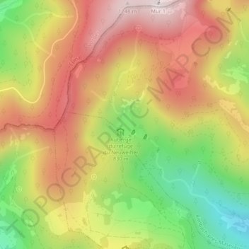
Grand Neuweiher topographic map
Interactive map
Click on the map to display elevation.
About this map
Name: Grand Neuweiher topographic map, elevation, terrain.
Average elevation: 941 m
Minimum elevation: 586 m
Maximum elevation: 1,248 m
Other topographic maps
Click on a map to view its topography, its elevation and its terrain.
Col du Ballon d'Alsace
France > Grand Est > Saint-Maurice-sur-Moselle
Col du Ballon d'Alsace, Route du Ballon d'Alsace, Saint-Maurice-sur-Moselle, Belfort, Territoire-de-Belfort, Grand Est, France métropolitaine, 88560, France
Average elevation: 996 m
Tête des perches
France > Grand Est > Saint-Maurice-sur-Moselle
Tête des perches, Saint-Maurice-sur-Moselle, Épinal, Vosges, Grand Est, France métropolitaine, 88560, France
Average elevation: 1,003 m
Haute Bers
France > Grand Est > Saint-Maurice-sur-Moselle
Haute Bers, Saint-Maurice-sur-Moselle, Épinal, Vosges, Grand Est, France métropolitaine, 88560, France
Average elevation: 1,022 m