
Mount Edwards topographic map
Interactive map
Click on the map to display elevation.
About this map
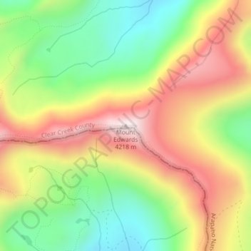
Name: Mount Edwards topographic map, elevation, terrain.
Location: Mount Edwards, Clear Creek County, Colorado, United States (39.63633 -105.79395 39.63643 -105.79385)
Average elevation: 3,871 m
Minimum elevation: 3,562 m
Maximum elevation: 4,215 m
Other topographic maps
Click on a map to view its topography, its elevation and its terrain.
Idaho Springs
United States > Colorado > Clear Creek County
Idaho Springs, Clear Creek County, Colorado, 80452, United States
Average elevation: 2,663 m
Blue Valley
United States > Colorado > Clear Creek County > Blue Valley
Blue Valley, Clear Creek County, Colorado, 80254, United States
Average elevation: 2,966 m