
Town of Cambridge topographic map
Interactive map
Click on the map to display elevation.
About this map
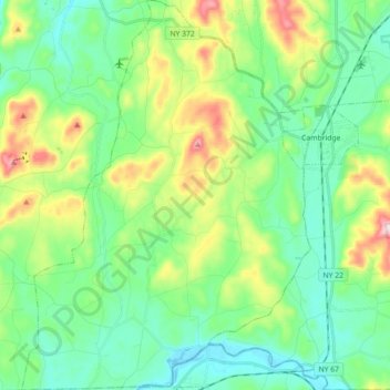
Name: Town of Cambridge topographic map, elevation, terrain.
Average elevation: 202 m
Minimum elevation: 102 m
Maximum elevation: 460 m
Other topographic maps
Click on a map to view its topography, its elevation and its terrain.
Lee
United States > New York > Washington County > Town of Cambridge
Lee, Town of Cambridge, Washington County, New York, 12028, United States
Average elevation: 150 m
Town of Hampton
United States > New York > Washington County
Town of Hampton, Washington County, New York, 12837, United States
Average elevation: 170 m
Black Mountain
United States > New York > Washington County
Black Mountain, Town of Dresden, Washington County, New York, 12841, United States
Average elevation: 487 m