
Cook County topographic map
Interactive map
Click on the map to display elevation.
About this map
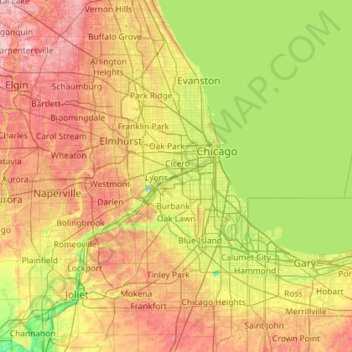
Name: Cook County topographic map, elevation, terrain.
Location: Cook County, Illinois, Verenigde Staten (41.46971 -88.26364 42.15429 -87.11053)
Average elevation: 199 m
Minimum elevation: 143 m
Maximum elevation: 289 m
Other topographic maps
Click on a map to view its topography, its elevation and its terrain.
Glencoe
Verenigde Staten > Illinois > Cook County
Glencoe, New Trier Township, Cook County, Illinois, 60022, Verenigde Staten
Average elevation: 194 m
Schaumburg Road Grasslands
Verenigde Staten > Illinois > Cook County
Schaumburg Road Grasslands, Hanover Township, Cook County, Illinois, 60107, Verenigde Staten
Average elevation: 246 m
Chicago
Verenigde Staten > Illinois > Cook County
Chicago, Cook County, Illinois, Verenigde Staten
Average elevation: 182 m