
Isle of Arran topographic map
Interactive map
Click on the map to display elevation.
About this map
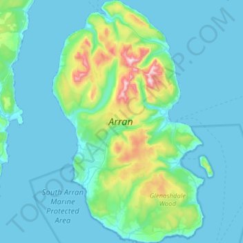
Name: Isle of Arran topographic map, elevation, terrain.
Location: Isle of Arran, North Ayrshire, Scotland, United Kingdom (55.43377 -5.39702 55.72122 -5.07897)
Average elevation: 98 m
Minimum elevation: -1 m
Maximum elevation: 853 m
The island has three endemic species of tree, the Arran whitebeams. These trees are the Scottish or Arran whitebeam (Sorbus arranensis), the bastard mountain ash or cut-leaved whitebeam (Sorbus pseudofennica) and the Catacol whitebeam (Sorbus pseudomeinichii). If rarity is measured by numbers alone they are amongst the most endangered tree species in the world. The trees grow in Glen Diomhan off Glen Catacol which was formerly a National Nature Reserve. Although this designation was removed in 2011 the area continues to form part of a designated Site of Special Scientific Interest (SSSI), and is monitored by staff from NatureScot. Only 236 Sorbus pseudofennica and 283 Sorbus arranensis were recorded as mature trees in 1980. They are typically trees of the mountain slopes, close to the tree line. However, they will grow at lower altitudes, and are being preserved within Brodick Country Park.
Other topographic maps
Click on a map to view its topography, its elevation and its terrain.
Largs
United Kingdom > Scotland > North Ayrshire
Largs, North Ayrshire, Scotland, KA30 8AA, United Kingdom
Average elevation: 110 m
Ardrossan
United Kingdom > Scotland > North Ayrshire > Ardrossan
Ardrossan, North Ayrshire, Scotland, KA22 8BS, United Kingdom
Average elevation: 21 m